The Providence Harbor waterfront, including the Port of Providence...how many have taken a leisure view of one of the only two deep water ports in New England? After you have paddled the Narragansett Bay and adjoining waters for some time, you start looking for things that you might have overlooked. Enough of the flocks of a hundred Mute Swans swimming across the Bay, enough of the Canada Geese, enough of the crowded beaches, enough of the same paddles year after year. We want something different for a change. We paddle the Bay to escape the daily life and surroundings to find a little adventure or maybe a little quiet on the Bay, but this time we go looking for things man made.
In daily life we have more in common with the Providence industrial waterfront than we have with the birds, fish and estuaries of Narragansett Bay. If we heat our homes with fuel oil, or even coal, it is delivered through the Port of Providence. The roads we drive on are covered with asphalt that is delivered through the Port, as is the salt used in the Winter to keep us on the roads. Heat with Propane gas? That also comes through the Port. If you buy a new car and the old one gets scrapped, it probably was crushed and shipped overseas as scrap metal to China, leaving through the Port. So lets take a paddle and see if we can identify some of the 20 or so companies that depend on waterfront access for their business.
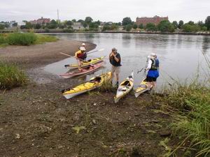
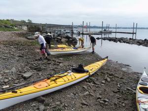
Bold Point launch beach
This paddle is the domain of a regular sea kayak, so we prepare for the paddle the same as we do for an open water paddle in the lower part of Narragansett Bay. A convenient launch point is at Bold Point, across from the new India Point Park, one of the many Rhode Island State fishing accesses.
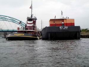
Docking an oil barge
Paddling down a short stretch of the Seekonk River we notice a tug boat moving up the Providence River, pushing an oil barge , so we waited for 15 minutes until we could cross astern. This boat and its sister tugs once belonged to the Providence Steamboat Company, but recently were sold to Mcallister Towing of NY. The Providence Steamboat Company was founded by Frank Mauran in 1881 when the tugs were really steamboats The prop wash from the tug was interesting to cross as we headed up the River to investigate the Providence downtown waterfront on a Sunday morning.
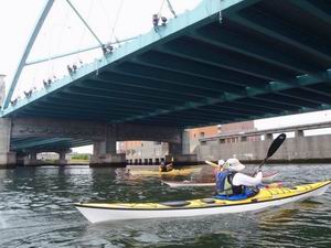
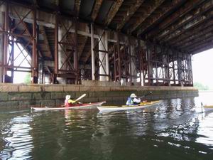
Passing under the new Rt 195 bridge
The first structure we paddled under was the new Rt 195 overpass, which was constructed at Quonset Point and floated up the Bay. By carefully using the tidal level change, it was lowered onto the bridge foundations. The wired construction makes it look flimsy, but wire stayed bridges are the norm today. The new cable stayed bridge in Boston in another example of a modern bridge. Just beyond that is the Fox Point Hurricane Barrier which has three Trainer type gates to be lowered to prevent any hurricane flood surge from flooding Providence as it did in 1938.
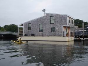
Houseboat in river
Once inside the hurricane barrier, and passing the old Narragansett Electric Power Plant, now converted to burn natural gas, we examine a houseboat. Functional and very neat, but lacking the uniqueness of the houseboats in the Sausalito harbor in California.
Paddling under Rt 195
Paddling up the channel we go under the Point St. Bridge and then under the Rt 195 bridge, which has been reinforced with additional steel beams to supplement the concrete posts. Makes you wonder with all the additional bracing how much longer the bridge would have lasted if if were not for the new highway project.
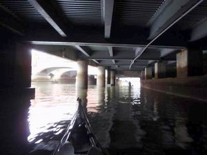
Under the streets of Providence
We paddle under several nice waterfront bridges leading up to Waterplace Park. With a eye on our time we decided to stop under the Providence Place Mall and turn around to head south. Very strange paddling under the street to the side of the open river. It even goes under farther than the photo shows. Heading back to the hurricane barrier, we pass the shell of the old electric power plant, with a huge sign advertising the Dynamo House, a proposed development that seems to have been abandoned. Even the web address on the sign is not active anymore. So much for grand development schemes. Maybe someday?
Hurricane Barrier gate
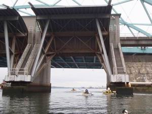
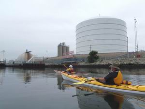
As we pass through the hurricane barrier we can see the size of the gates. We now approach the Providence Port area which is operated by the Waterson Terminal Services. The first things we see are the large oil tanks operated by the Sprague Energy company. Later we come upon a worker leaning over the railing of a fishing trawler and with a roller brush, repainting the hull.
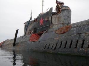
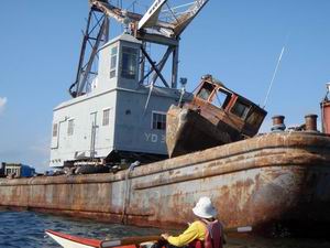
Russian Submarine to be scrapped.
Then as we come upon the Promet Marine Services dock, we see vessels waiting to be scrapped. A couple of burnt out tugs, an old Prudence Island ferry, and the Russian submarine. The sub was finally floated (the Navy used it as a salvage exercise), after it sank during a storm in 2007. It now sadly sits waiting for the cutting torch.
Paddling by propane tank
With all the debate on locating LNG storage tanks in Weaver Cove in Fall River, a liquefied Propane storage facility and tank sits on the Providence waterfront. Next, going south along the waterfront, we find the portland cement off loading facilities. Portland cement is the binding agent in concrete.
Tug pushing freighter to the dock.
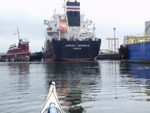
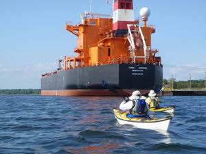
As we passed the cement barge, we noticed a large freighter coming up the channel and appearing to head toward the docks. When ships that big are moving around, you always try to keep well out of their way. While when crossing a highway with a bike, motorists sometimes illegally stop to let you cross, ( that is a whole other digression), but a ship will show no such caution. But they always will signal their intentions, a few horn blasts will do it. As we sat along the docks waiting to see if the ship was going farther up the channel or getting ready to dock, it gave several double toots. I was not sure it they were tooting at us or someone else, but two short toots means passing or going port side (that is to the left). So using my VHF radio I called the tug on channel 13 as to their intentions. At first I called the tug by the wrong name, but once we could see the name, (The Reliance, the same one that we passed starting the paddle.) we called again and they answered that they were docking just south of us. So we sat watching the show as the tug pushed the freighter sideways up to the Hudson Asphalt terminal.
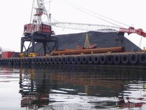
Coal pile on wharf.
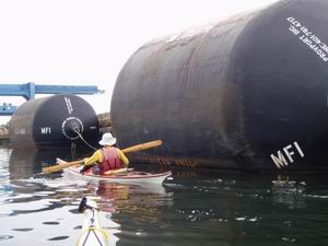
Large ship bumpers
Proceeding south, we passed the newly replenished coal pile, operated by the Waterson Terminal , which is obviously much larger than seen earlier in the summer. We paddled by several huge floating bumpers, the largest I have ever seen. I whacked one to see if it was soft like a balloon, which it was not, more like kicking a huge truck tire. Next down the waterfront we could see the scrap steel pile waiting to be loaded on to a freighter at the Metals Recycling Company. The pile seemed smaller than earlier in the season.
Landing at Save the Bay
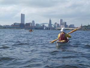
Paddling south around Fields Point, itself the product of dredge spoils from the harbor, we pulled into a small sheltered mini-harbor next to the Save The Bay organization's building. It was about time to have some lunch so we used their picnic tables on the patio. From there, still paddling south, we left the industrial area and headed into Pawtuxet Cove to check out the rapids at the mouth of the Pawtuxet River.
Oil tanker docked at Exxon Mobil
So as to not retrace our route, we crossed the Bay to Sabin Point Park and from there up the eastern side of the upper Bay. We passed the Pomham lighthouse and cruised next to a large oil freighter docked at the Exxon Mobil terminal in East Providence. Next up the coast is the Squantum Association, an building dating back to 1872, which belongs to a private club, but is open to public and private events such as weddings.
Barge with boat on deck.
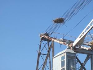
Osprey nest on cables
Farther up the east side of the Bay we came across an old gray navy crane (the YD designation is the clue) that has a strange nest on the upper cables and a rusting boat on deck.
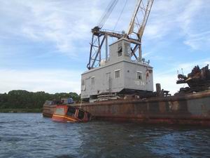
Earlier photo with boat in water.
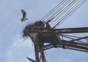
Osprey landing in nest.
Earlier in the summer, when we were scouting out the paddle, we saw the same barge but the nest was on top of the girders. We even saw a osprey feeding chicks. Obviously the boat was lifted out of the water and placed on deck. In doing so, the nest was dragged along on the cables. Did the operators wait until all the chicks were out before they lifted the boat on deck? We hope so!
Heading back to Bold Point launch site.
Finally after about 14 miles of paddling, we come back to the Bold Point launch point to finish a very interesting day. If you wish to see all the photos of the paddle, view the Photo Album.
References on the Internet:
--A
Century of Change:Providence Harbor Shorelines
--Businesses
located on waterfront.(23MB pdf)
--Providence
Port web page.
--Providence
Working Waterfront Alliance
--Providence
Harbor Then & Now (photos)