.
Hiking and Backpacking Resources
(Any reference to a specific dealer is not an endorsement, but only a suggested source.)
Gear for Local Hikes and suggestions for new members.
- Foot wear for hiking: This important item should be suitable for rough terrain. Shoes or hiking boots can be found in discount stores to sporting good stores. Heavier socks are needed for comfort. Bring an extra pair for wet conditions.
- Clothing: Synthetics will wick water away from you skin and is better than cotton because it adsorbs water. Synthetic fleece and wool will keep you warm even wet during cold weather. Synthetic pants are best for hiking and those designed for hiking are the most comfortable. Have rain gear, wind breakers, jackets, hats and mittens to counter the weather conditions.
- Backpacks, Hiking Poles: Small backpacks can be found at many retailers. They should be large eought to carry what you need. Fanny packs if large enough are good for some local hikes. Hiking poles have been found at discount stores.
- Items to bring for local day hikes: Extra clothing, insect repellent, sunscreen, personal medications, sunglasses, first aid items, snacks, plenty of water, cameras.
An Introduction to Backpacking
Class notes on beginning backpacking. Things to know and how to prepare for backpacking safely and comfortably. Presentation by Jim Swanberg of the Northern Hiking Committee
Hiking with Kids
AMC has a new site just for Kids. Want to find ideas for getting your kids outside and having fun? See the new Kids Outdoors site.
Winter Hiking Equipment and Clothing
The Northern Hiking committee presented a Seminar on winter gear and clothing at REI Cranston on Dec. 2, 2010. The linked article is derived from the handouts provided by the AMC leaders. Information is provided on clothing, boots, gear, and etiquette. Click here to read more.
Safety Notes
Here are some rules and practices that are best followed to decrease your chances of becoming lost, injured, or diseased.
Hike Safe Card
(new) Your back-up plan in the great outdoors! Every purchase helps support N.H. Fish and Game search and rescue efforts. $25/person or $35/family. Good through the end of the calendar year. Exempts holder from rescue cost reimbursement. New in 2015, this could be a good investment considering it is less than you spend on gas driving from Rhode Island up and back to the White Mountains each time. Read more at their web site.
Search and Rescue
(new) Search and rescue (SAR) is the search for and provision of aid to people who are in distress or imminent danger. The general field of search and rescue includes many specialty sub-fields, typically determined by the type of terrain the search is conducted over. When you are out of USCG range kayaking, out of cell phone access in deep mountainous areas, or somewhere with no cell towers, it has become easier and cheaper to radio for help with modern SOS electronic devices with satellite coverage. Consider purchasing a SAR device if you possibly could be in a rescue situation. Before you purchase a device read these (and others) articles to understand how they work and which one suits your needs. "The Best Personal Locator Beacon and Satellite Messenger Review" and "PLBs and Satellite Messengers: How to Choose". The webmaster's personal pick would be the newer "Delorme InReach Explorer", based on personal experience over many years of their PN-Series Handheld GPS units. Articles often refer to the older SE InReach model. ACR also has newer models. Be sure you examine only the newer models of any device.
Proper use of Bug Repellants
Articles suggest that using DEET products and sunscreen together may not be in your best interest. But not all sources have the same recommendations. Read articles on the proper use of insect repellants by the US Center for Disease Control, one by Undercurrents magazine, and one by the Illinois Department of Public Health.
What to do in Tick season
As Spring returns to New England, the chance encounter with Lyme Disease returns. Those who have had the disease or still have it, will tell you...Don't takes chances! So what to do? Read up on methods of identification and prevention at the URI Tick Encounter Resource Center.
What kind of insect repellant is best? DEET is the most commonly referred repellant for insects, but not the most effective for ticks. Many studies show that Permethrin based products are better. Before you start reading, note that Permethrin is highly toxic to cats. It is also a powerful fish repellant, so keep it out of your tackle box. It is not to be used on the skin and is mostly used as a treatment for clothing. It kills ticks on contact whereas DEET does not. Several articles are worth looking over to give you a good overview of both (and others) types of repellants. There are two brands locally available, "Repel" and "Sawyers", costing from $7-9 for 6-10 oz. pressurized cans, to $16 for a 24 oz. spray bottle. Most likely found in Camping/Hiking or Hunting/Fishing stores. Both brands contain 0.5% Permethrin.
Good Environmental Practices
Practices that preserve and protect your favorite hiking areas for others, now and in the future.
Winter Hiking Leave No Trace Techniques
As a growing number of skiers, snowboarders, snowshoers, telemarkers venture out in winter for day or overnight trips, the need to practice Leave No Trace winter techniques is now greater than ever. Click here to read more.
Resources
Websites that promote, support and provide information on hiking and backpacking.
White Mountain Parking Passes.
(new) Most White Mountain National Forest lands are open and free of charge for your use and enjoyment. Certain developed sites require payment of a recreation fee, which includes parking at many of the trail heads. Check the Forest Service web site for the fee schedule and more information on passes.
Group Notification System.
Each year the AMC-managed backcountry sites in the White Mountains and Mahoosuc Range host an average of 20,000 overnight visitors year round. Nine of the most popular sites see an average of 11,000 visitors in the summer months. More than one-third of those visitors — 35 percent — are part of an organized group. As use of these popular sites continues to be heavy, so does the impact on the forest, in terms of human waste, erosion of heavily used trails, and trampling of vegetation. To better manage these public wildlands so that all hikers continue to experience an uncivilized forest, we must receive pre-notification (this is not a formal reservation)from large groups concerning which sites they plan to use. Read more...
White Mountain Hiker Shuttle operates daily from June 3 through September 12, and on weekends and holidays from September 18 through October 17. Don't spot cars, use the Hiker Shuttle.
Great Swamp Press Great Swamp Press publishes authoritative maps and guides for hiking in recreational areas in and near Rhode Island, plus maps and guides of historic and architectural interest. Old fashioned field research, the latest technology and top quality materials provide you with the most accurate, completely detailed, yet easy to read maps available.
Hiking Maps and Guides
Various Web sources that have information on hiking in New England.
- HikeNewEngland.com. The goal of this website is to provide free information for people hiking, walking, or snowshoeing in New England. We currently offer over 200 trail reports – written both by the Webmaster as well as other outdoor lovers. These guides are usually pretty detailed and include a description of the hike, trail distances, a difficulty rating, and driving directions; often photos or trail maps are also provided.
- REI Guidepost. An interactive (Trails.com) outdoor guide to various activities, including hiking, based on your computer location (your IP address). You can also type in a search destination. The content is provided by Trail.com and promotes signing up to Trails.com if you are a REI member for a reduced price of $30. Uses Google maps, and tested by webmaster in Opera, Firefox, Chrome, Safari(Windows) and IE8. Tested on Win XP, Win 8, Android browsers and iPhone browsers. The application does not work properly in all browsers, what does not work in Win XP may work in Win 8, and visa versa. So if one browser does not work for you, try another browser. Mobile applications are even more of a problem if your browser of choice automatically brings up the REI mobile version, which does not have the Guidepost application.
- AMC "Plan Your Own Trip" This Outdoors.org page has AMC information on trip ideas, guide books, maps and other planning resources. The "Hiking and Backpacking Resources" page includes extensive links to almost everything you might want to know about AMC hiking including articles in the AMC archives.
- White Mountain Guide Online This interactive mapping application is AMC's online edition of the White Mountain Guide which has descriptions of over 500 trails and detailed maps in an online format that is easy to use and continually updated as conditions change, including post-Irene trail conditions. All for one low annual subscription fee of $15 ($12 for AMC members). Note from webmaster: This application works only in Internet Explorer and Firefox (as per online stated requirements.) But the webmaster could not get the Trial version to work in any browser, Win XP or Win 8. Seems to have problems with cookies or encryption, even though cookies (don't even ask) are available. So be sure to try the Trial version before subscribing.
- National Geographic Maps Has their Trails Illustrated Maps and their Topo! State Map series. The Trails Illustrated maps are excellent for National Parks and more well known recreation areas. Sorry no RI trails. The Topo! State series include five layers of maps that include 3D views and fly-throughs, elevation profiling that allows you to draw a route and immediately calculate elevation gain or loss, and live map updating that lets you search for and download updated USGS quads. Note from webmaster: the current Topo! maps have been compresses somewhat more than the original Topo! maps (NG bought Topo!), so if you still have the old Topo! State maps, keep them for the better resolution, although with not all interactive functionality of the NG version.
- Delorme Maps Well known for it's "Atlas & Gazetteers" for each State. These paper maps cover all the roads and some trails that official State maps sometimes do not show. Essential for preliminary planning and sometimes for getting to a trail head that you know where it is, just don't know what road to use to get there.
- Explore Rhode Island's Blueways and Greenways This site is a partnership between the Rhode Island Blueways Alliance and the Rhode Island Land Trust Council. The Land Trust Council information is about RI trails. The Rhode Island Blueways Alliance is about paddling opportunities in RI. "The Blueways project began in 2006 when the Rhode Island Rivers Council and the National Park Service Rivers & Trails program brought together diverse interests from throughout the state to discuss and plan a comprehensive water trail network. The trails would link Rhode Island's rivers, lakes and ponds to Narragansett Bay and to the rivers in Massachsuetts that flow into the bay, and be used to promote safety, conservation, recreation and economic development. The Rhode Island Blueways Alliance incorporated in the state of Rhode Island as a non-profit corporation in late 2007 and now manages the Blueways project and this web site."
Find your Favorite Hiking or Walking Trail
Hiking Areas in Rhode Island State Parks, Preserves, and Recreation Areas
Rhode Island has many parks, recreation areas, preserves, beaches and campgrounds, all managed by the RIDEM. Many are suitable for hiking and walks. The ones listed below offer sufficient space for short hikes, or long walks. All the State Parks can be found by region with this map. The page uses Google Maps so it is a large site to download.
Aerial photographs are useful to explore various hiking areas. All aerial photos on this page are interactive, which means you can pan and zoom the image. The largest size saved (via screen capture) is limited by the size of your display monitor. The photos are not necessarily taken in the Spring and tree leaves will obscure some trails. (Some images over the Bay are currently to dark to view details.) The photos are taken at various times, the latest in Rhode Island are May 1, 2010.
- Beavertail State Park - is less than a mile long and only about 1/2 mile wide and consists of dense brush, open field and a perimeter road. While more suited for easy walks, it offers shoreline scrambling and wide open view of the ocean. (Google Map)
- Brenton Point State Park - has a similar terrain mostly suited for easy walking, and again a magnificent view along the ocean shoreline. (Google Map)
- Colt State Park - is large enough that long walks or short hikes are possible. It is 2 1/2 miles long and at the widest 3/4 mile. Being up farther in the Bay it has a gentler shoreline and none of the surf that Beavertail and Brenton have. Any walks from the park can be enhanced by the multiple-use bike path that runs through part of the park. The chapter has hikes (and bike rides) in this park each year. ( (Google Map)
- Fort Wetherill State Park - is suitable for short walks. It has high bluffs and coastal fort emplacements that offer a grand view to the south out over the ocean. (Google Map)
- Goddard Memorial State Park - is probably one of the most popular parks in the State. Quite large and suitable for long walks or short hikes. It offers trails and roadways and large grassy areas for recreation. The entire property has shoreline on Greenwich Cove of which a large part of it is adjacent to the hiking paths. It is about 2 miles long and 3/4 mile wide. This is a full service park with bathing beach, restrooms, etc. This park is used by our chapter often for mid week hikes. (Google Map)
- Lincoln Woods State Park - is another very popular park. Large enough for hiking and long walks. Plenty of woods to hike in and large grassy areas. A perimeter road around the Pond are a very popular place for walking and exercising. This is also a full service park, with a small sandy beach front area for swimming. The chapter has several hikes at this park each year. (Google Map)
- Pulaski Memorial Recreation Area - is a 100 acre park in the northern part of the State and is within the 4000 acre George Washington Management Area. There are more than 10 miles of trails which can be hiked in the summer or skied in the winter. (Google Map)
- Snake Den State Park - is a 1000 acre undeveloped area which has plenty of hills and trails to hike on. This park has a hilltop view of Providence about 5 miles away. The chapter hikes this park at least once a year. (Google Map)
- John H. Chafee Nature Preserve - Commonly referred to as Rome Point. This is a RIDEM managed site with the town of North Kingstown holding a conservation easement over the land. It consists of 230 acres traversed by a series of trails leading to Narragansett Bay. Very popular for seal watching in winter. Has several miles of trails. (Google Map)
For Serious Mapping Inquiries
(new) The RI DEM uses Geographic Information System (GIS) technology to create, manipulate and analyze spatial data that you can use in an interactive mode. Maps that may interest hikers are on the Interactive Digital Maps page. The "Topo Map & Aerial Photo Viewer" is described as a "...Fast & easy viewer including aerial photography dating back to 1939, USGS Topographic Maps, & NOAA Navigational Charts." This application uses the interactive arcGIS Explorer which allows you to view different maps, customize them and print. The interactive programs are difficult enough that you may want to look at the tutorial page on using GIS software that the DEM offers.
Trail Maps for Hikes in Rhode Island Wildlife Management Areas
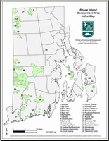
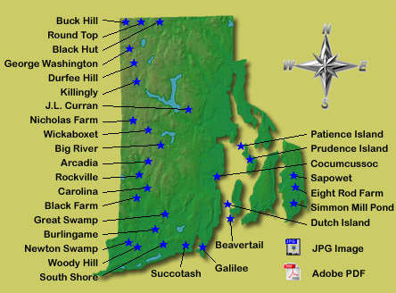
(new) Many of the woodland places to hike in Rhode Island are located in the State Wildlife Management Areas (WMA). The RI DEM has produced maps that are suitable for locating these areas and exploring the trails. Some trails are marked but not identified. The maps include topographic features. RIHunts.com includes WMA maps, including named trails (but no topographic features) on one set, and topographic maps on another set. All the maps are primarily designed to identify the boundaries of the State WMA's. Use the images below to start finding WMA maps.
Click either image for maps.
Hiking Trails in National Wildlife Refuges in Rhode Island
The new Kettle Pond Visitor Center and headquarters located in Charlestown, RI, is the central location that manages the five National Wildlife Refuges in the State. Several are suitable for hiking, the Ninigret National Wildlife Refuge, Sachuest Point National Wildlife Refuge, and the Trustom Pond National Wildlife Refuge. A location map of the refuges is on this page.
- Sachuest Point National Wildlife Refuge - is a point of land on the mouth of the Sakonnet River that has about 2 1/2 miles of level trails. This isolated peninsula has a modern visitors center and is ideal for ocean side walks. (Google Map)
- Ninigret National Wildlife Refuge - is a large parcel of land that is part of the previous Charlestown Naval Auxiliary Air station. The area has many trails and paths on the northern side of Ninigret Pond. The barrier beach is the longest undeveloped shoreline in Rhode Island and suitable for beach hiking. (Google Map)
- Trustom Pond National Wildlife Refuge - is also on the southern coastal area. It surrounds the state's only undeveloped salt pond. It is ideal for walks and but with less trails than the Ninigret area. The barrier beach is closed for part of the year due to nesting of the Piping Plover. (Google Map)
The Rhode Island North South Trail
This trail (although not a trail for the entire distance) runs from the Massachusetts border in the Buck Hill Management Area, to the Atlantic Ocean on East Beach Road, Charlestown, at Blue Shutters Beach. It consists of about 75 miles of trail that is a mix of trails, paths, and some roads. A map of the route is available, and a book describing the trail can be purchased at REI. (New) Topo Maps for the North-South trail are available.
Nearby Out-of-State areas
The Nature Conservancy in Rhode Island
There are many properties in Rhode Island under the ownership of the Nature Conservancy. Many of them have short trails suitable for walks and hikes. A map of the preserves can be used to investigate hikes. Use the Visit tab to see the Google maps. All the preserves require that you honor their rules and conditions for visitation.
Rhode Island Land Trusts
(new) There are many land trusts in Rhode Island, some offer hiking and walks. Some require visitation is by scheduled walks only. The following are some of the more popular ones, and can be visited without scheduling.
The Audubon Society of Rhode Island
Audubon maintains nearly 9,500 acres, including 13 refuges in Rhode Island and nearby Massachusetts which are open to the public and have groomed trails for hiking and other nature activities. The Society requires that you abide by their rules to ensure that the refuges remain as healthy habitats. The following areas are suitable for hikes of walks from 3 to 5 miles.
Town and Municipal Parks and Recreation Areas
Many of the town and cities of Rhode Island have places to hike as a result of the rugged terrain and unbuildable land. Many towns and cities also are becoming concerned with the open land and farms being developed and have taken advantage of special conservation easements. The result is a variety of landscapes suitable for hiking and walks. A few are listed below.
- Cumberland Monastery Grounds - located on the site of a former Cistercian Monastery, is owned and maintained by the Town of Cumberland. There are several miles of trails in an area about one mile square. (Google Map)
- Birchwold Farms and Joe's Rock - located in Wrentham near Diamond Hill State Park (now Cumberland Diamond Hill Park). This conservation area in Massachsetts offers several miles of trails on 129 acres of woodland and open fields. Adjacent across Rt 121 is Joe's Rock which gives a view of a pond and Providence way to the south. See photos in the Photo Album and Conservation pages. (Google Map)
- The Newport Cliff Walk - is about 3 1/2 miles long (7 mile round trip) along the ocean cliffs behind the opulent Newport Mansions, of which about 2/3 of the trail is an easy walk on paved sidewalk, but the southern end is over rocky terrain. It was designated a National Recreation Trail in 1975. (Google Map)
- Osamequin Nature Trails and Bird Sanctuary, Barrington - has two to three miles of trails in the sanctuary adjacent to Hundred Acre Cove and bordering wetlands. Just off Rt 114/103. (Google Map)
- Napatree Point Beach - This is a favorite beach walk at Watch Hill in the Fall when all the tourists have left the area. Easy parking and access. The hike out and back is about 3 miles. (Google Map)
- Wolf Hill Conservation Area - This is a network of trails that start near the Smithfield Conservation Center on Pleasant Ave. More Hiking trails in Smithfield Conservation are no longer listed on the Smithfield Town website. See the Photo Album for a previous hike in this area. (Google Map)
- Neutaconkanut Hill Park (King Park) This recreation park is owned by the City of Providence, and is currently getting more attention and appreciation. Neutaconkanut is the highest point in Providence and consist of 88 acres of open space adjacent to the town of Johnston. Parking is at the Neutaconkanut Hill Recreation Center on Plainfield St. (Google Map)
Massachusetts Dept. of Conservation and Recreations Areas
There are many places to walk and hike near Rhode Island in neighboring Massachusetts. Below are places of interest.
Massachusetts Dept. of Conservation and Recreation - This page has trail maps for online viewing or downloading of Mass. State Parks, State Forests and Conservation Areas.
Commercial Maps and Books for hiking in Rhode Island
- Great Swamp Press - Great Swamp Press publishes authoritative maps and guides for hiking and mountain biking in recreational areas in and near Rhode Island, plus maps and guides of historic and architectural interest. Old fashioned field research, the latest technology and top quality materials provide you with the most accurate, completely detailed, yet easy to read maps available. They have specific maps for Arcadia, Big River, Carolina & Burlingame, Long & Ell Ponds, North South Trail, Pachaug, and Cliff Walk & Bellevue Avenue.
- The Map Center - Located on North Mail St. just above Branch Ave Exit from Rt 95 has a selection of maps and books for hiking in RI.
- Various online books - Amazon (there are other distributors) has a selection under a search of "rhode island hiking".
- Books by Ken Weber - Currently two books are available in his "Walks and Rambles in Rhode Island".
rev. Dec. 1, 2013
Home |
Welcome |
Join |
Renew |
Chapters |
Search |
Contact Us |
Privacy Policy
Photo Credits (unless noted) - Michael Krabach
Contents copyright © 2006-2017 The Narragansett Chapter AMC
How are we doing? Give us feedback on this site.
Rev. Jan. 14, 2017